|
|
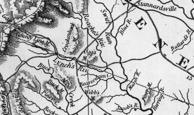
Map of the northwest corner of Albemarle, along the Greene/Albemarle Co. border. Buck Mountain Creek, County Line Mountain, Buck Mountain and Roach's River (right over the border in Greene Co.) are located in this section. This border was first the Hanover and Spotsylvania border, before Albemarle was formed. In 1738, both William Coursey and Thomas Ballard received patents for land on the south side of Piney Mountain. In 1743, Fredericksville Parish processioning listed these land owners: Thomas Ballard, Abraham Allen, William Coursey, and John Poindexter. In 1741 and 1746, Samuel Garlick, of Caroline Co., received patents for 3600 acres along Buck Mountain Creek, and in 1747 John Whatley received 400 acres in "Hanover County . . .on both sides of the south Fork of Buckmountain Creek . . . .At Robert Thompsons and John Hackets Corner. " This map shows Piney Mountain, sometimes called Poindexter's for John Poindexter. His patent of 1738 for 400 acres in Hanover County "on SW side Poindexter's alias Piney Mountian" adjoining his own land. In 1749, on a deed of sale from William Coursey to John Dickenson, Coursey sells a section of land and the deed mentions " where John Shiflet formerly lived on the lower side of Piney Mt." Note the Herring River which runs along the east side of Piney Mountain. (This is probably John Shiflet Sr., not the John who m. Joice Powell.)
In 1820, another John Shiffalette received a grant
for 85 acres on " Lick Spring or County Line Mountain" and in 1836,
Jacob Shifflet (Shiplet) received a grant for 38
1/4 acres on the east side of Lick Mountain, adjoining land he already owned.
Thomas and Patience Shiflett lived along Lynche's River between County Line
and Piney Mountains.
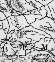  |
Southerly continuation of the map above, showing Moorman's River,
the South Fork of the Rivanna, Pritty's Creek, and the Poor House. The Rivanna
was aka the North Fork of the James and the North River. The Fluvanna was known
as the South River. Also shown is part of the Southwest Mountains, also known
as the Chestnut or Little Mountains. These mountains continue southeasterly as
the Carter Mountains on the other side of Charlottesville. In 1809, Lewis Shiflett,
son of John, received a re-issued grant in his own
name for 220 1/2 acres on the waters of Meadow and Ivy Creeks, adjoining the lands
of Susannah Phillips, Thomas Burton, Richard Burch, David Wade and George Booth.
This was the homeplace of John and Joice Powell Shiflett. The heirs of John Shiflett
deeded their interest in this land to Lewis. Land Plat.