|
AN UNEXPECTED GEM | |
 Border by Mission Home |
|
| | |
|
|||||||
| |
Prize Hill and the Mountains | ||
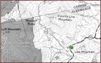 | |||
| The green circle marks the location of Prize Hill, sitting at the base of Lick Mountain. Across the road is a foothill of County Line Mountain. Northwest is Mission Home and Loft Mountain, also known as Frazier Mountain. The water runs at the top of the map are branches of Lynches River. Those in the southern part feed into Buck Mountain Creek. If you have read the early deeds on the site, all these names should be familiar to you. The shaded area is part of Shenandoah National Park. | |||
| |
||
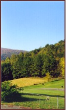
| The beauty of the area is hard to capture. | 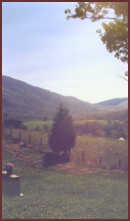 |
| |
On Tuesday I went back to Prize Hill to try to record all the graves, but I found an unexpected gem of information. My Anonymous Tour Guide (ATG) showed up, and after some questioning to make sure I understood correctly, told me the location of: | |
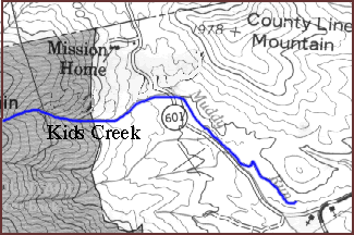 |
flowing down Loft Mtn. changing into Muddy Run |
|
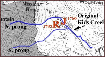
In 1760, John Ogg sold John Shiftlett Sr. 120 a. at the foot of the Mountains on Kids Creek. Both the east and west sides of Kids Creek were boundaries. According to my ATG, the PATC map we're using here is incorrect-- Kids Creek flows past 601 and doesn't turn into Muddy Run until further down. This makes sense when we look at a deed of 1783. | ||
| |
In 1783, Benj. Huntsman sold Richard Shiflett 74 a. “on one of the Branches of James River being hide Creek Joynin The Lands belonging to Thomas Sanford and John Shifflet. . . to red oak on the South Prang of Kids Creek thence to a Larg red oak on Same creek . . . Thence North prong of Kids Crek to the fourth whare we began.” So Muddy Run was once called Hide's Creek. What PATC has labeled Muddy Run on the map, was (and still is to the people who live there) Kids Creek. 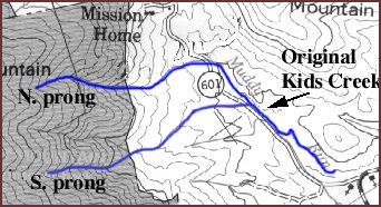 |
| |
If Richard's land was between the north and south prongs of Kid's Creek, and it adjoined John's land which lay on both the east and west banks of Kid's Creek, then their land was probably located right about here, between Prize Hill and Mission Home: |
 Send me an e-mail and let me know what you think. |
| |
|
©1999 Copyright for these pages and the information contained thereon lies with the submitter or maintainer named on each page. Reproduction or commercial use of any kind is strictly and expressly prohibited. This page is part of the Shiflet Family Genealogy Website and is maintained by: Julia Crosswell / Fort Worth, TX / 1998 - 2006 Robert Klein / Pasadena, MD / 2008 - present |